


st-Jacques le puy à Nabisnal

dehemjacques
User
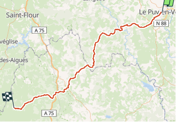

Length
117 km

Max alt
1336 m

Uphill gradient
3040 m
Km-Effort
156 km

Min alt
592 m

Downhill gradient
2520 m
Boucle
No
Creation date :
2023-06-02 16:57:17.593
Updated on :
2023-06-02 16:57:24.794
35h25
Difficulty : Medium

FREE GPS app for hiking
 SityTrail
IGN / Geographical institutes
SityTrail Plus
The world is yours!
About
Trail Walking of 117 km to be discovered at Auvergne-Rhône-Alpes, Haute-Loire, Le Puy-en-Velay. This trail is proposed by dehemjacques.
Positioning
Country:
France
Region :
Auvergne-Rhône-Alpes
Department/Province :
Haute-Loire
Municipality :
Le Puy-en-Velay
Location:
Unknown
Start:(Dec)
Start:(UTM)
569210 ; 4988076 (31T) N.
Comments